![]()
![]()
![]()
![]()
![]()
![]()
![]()
![]()
![]()
![]()
![]()
![]()
Integrated analysis of spatial and attribute data
Retrieval/classification/measurement
functions
Overlay operations
Neighbourhood operations
Connectivity functions
These GIS operations are especially applicable to environmental
modelling.
Retrieval/classification/measurement
functions
Spatial and attribute data are retrieved but only the
attribute data are modified or created, no changes are made to the spatial
elements.
- Retrieval operations
involved selective search, manipulation and output of data.
- Classification
is the procedure of identifying a set of features belonging to a group
and assigning a name to that group.
- Measurement functions
is the calculation of distances between points, length of lines, perimeters
and areas of polygons and the size of a group of cells with the same
class.
|
This is divided into arithmetical and logical overlay.
|
Overlay of flood zone with
cadastral map 20kb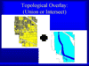
|
![]()
These evaluate the characteristics of the area surrounding
a specified location - include operations such as search, line in polygon,
point in polygon, topographic functions, theissen polygons, interpolation,
contour generation
- Search assigns a value to each target feature
according to some characteristic of its neighbourhood. The search area
is commonly a square, rectangle or circular with the size selected by
the operator. The search area is often termed a 'window'. There are
2 types of search functions - those that operate on numerical data and
those that operate on thematic data
- Numeric functions
are functions like the total, average, maximum, minimum and measures
of diversity (variance or standard deviation)
- Thematic functions
are functions like the majority, maximum, minimum and diversity
(number of different classes)
- Numeric functions
are functions like the total, average, maximum, minimum and measures
of diversity (variance or standard deviation)
- Line-in-polygon and point-in-polygon operations
this is the identification of points and lines contained within polygons.
In vector GIS this is a search function in raster GIS this is essentially
an overlay operation.
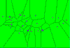
- Topographic functions topography relates to surface characteristics ie relief. Topographic functions are used to calculate values that describe the topography at specific geographic locations or in the vicinity of locations eg aspect at the location or slope of the area around the location.
![]()
|
Contours kb |
![]()
These are operations that use functions that accumulate
values over the area being traversed eg contiguity measures, proximity,
network, spread, seek, intervisibility, illumination, perspective view.
- Contiguity
measures evaluate characteristics of spatial units that are connected.
Common measures are the size of the contiguous area and shortest and
longest straight-line distances across the area.
- Proximity
is a measure of the distance between features. A common proximity function
is buffer zone generation. A buffer zone is an area of specified width
drawn around one or more map features.
- Network functions
A network is a set of interconnected linear features that form a pattern
or framework. Networks are commonly used for moving resources from one
location to another. There are 3 principal types of network analyses
that GIS perform
- network loading
eg predicting flows of water through a stream network
- route optimisation
eg routing of emergency vehicles
- resource allocation.eg division of an area into service zones
- network loading
eg predicting flows of water through a stream network
![]()
- Spread evaluates
phenomena that accumulate with distance eg it can be used to evaluate
transportation time or cost over a complex surface. Spread functions
have characteristics of proximity and network functions. They can generate
accumulation surfaces.
- Seek (or stream
function) performs a directed search outward in a step-by-step manner
from a start location using a specified decision rule.
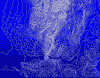
|
Viewshed 20 kb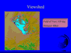
|
- Illumination
portrays the effect of shining a light onto a 3-dimensional surface.
The output is a shaded relief image. This function is controlled by:
- the position of the illumination
source,
- the topography and reflectance
of the surface
- the position and direction
from which the model is viewed
- the position of the illumination
source,
- Perspective A
perspective view is a surface portrayed from a viewing position other
than vertical. These are primarily presentation tools, useful for showing
3-dimensionality of features on a surface.
(Aranoff, 1989)