![]()
![]()
![]()
![]()
![]()
![]()
![]()
![]()
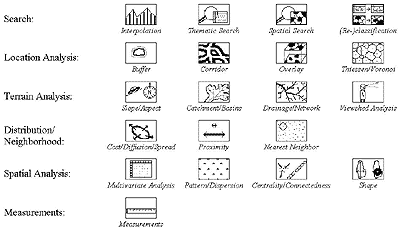
GIS functions
Below are some of the most common GIS functions broken down by the type of analysis they perform but it is also common to group GIS function into 4 major categories.
|
Which of these functions do you think are important for environmental
applications? Which could help address the sort of spatial and temporal
analysis discussed in Theme 1? |
||
|
Relating functions
to purpose
|
|
|
|
List some of the possible functions you might need to use if you wanted to look at the distance between patches and produce a map of your results. |
||
|
http:/www.geog.ubc.ca/courses/klink See NCGIA notes, this provides further reading on 'Spatial relationships
in spatial analysis.' |
||