
![]()
![]()
![]()
![]()
![]()
![]()
![]()
![]()
![]()
The landscape today
Landscape structure
Landscape change
Landscape function
Features present in the Kellerberrin landscape today are predominantly human produced. Pattern largely follows a rectangular grid arrangement with blocks of agricultural land being inter-dispersed by clumps of remnant vegetation that are joined by fence lines or road verges. Some nature reserves are present, but mainly remnants exist on privately owned blocks of land.
| In 1993 there were only 459 patches of remnant vegetation in the Kellerberrin study site. These vary in size from less than 1ha to 1030ha. Of these, 270 were less than 10ha in size and 353 were less than 20ha (Saunders et al., 1993). These patches preserve only about 7% of the original native vegetation. | Patch in the wheatbelt 25kb 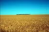
|
| The matrix in the Kellerberrin study site is the agricultural land. Patches of remnant vegetation exist in this 'sea' of agricultural vegetation. |
|
Corridors in Kellerberrin take the form of road verges and features such as drainage channels. These can connect patches of remnant vegetation and facilitate movement between patches. |
Corridors
in the wheatbelt 34kb 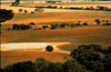
|
Because road verges make up a significant proportion of native vegetation remaining in the wheatbelt they are very important from a conservation point of view. The remnant vegetation and agricultural land are not isolated from each other: interaction takes place between them. A flow of water, nutrients and biota takes place between them (Hobbs et al., 1993).
Quantifying the structure
The landscape of Kellerberrin is similar in appearance to agricultural landscapes in North America. This means that standard fragmentation and structural indices should be applicable here. Indices that are appropriate for use in this landscape include measures of patch shape, patch spacing, area, perimeter, nearest neighbour, contagion and interdispersion.
![]()
Examination of the patterns visible in the landscape around Kellerberrin, reveal that fragmentation of habitat has been taking place. The Kellerberrin study site is a good example of fragmentation of habitat in Australia. Other examples include rainforest patches (Price et al., in press).
Associated with the structural changes in Kellerberrin, there have been major changes in the distribution and abundance of native vegetation, major changes in hydrological balance and other ecosystem processes.
![]()
Agricultural practices in the Kellerberrin area have resulted in the removal of perennial vegetation and replaced this with annual crops and pasture. Associated with the resulting structural changes are large changes in water and nutrient cycles, radiation and wind cycles. The loss of perennials can lead to reduced evapotranspiration, altered soil water flows with run off increasing and water tables rising causing salination.
![]()