![]()
![]()
![]()
![]()
![]()
![]()
![]()
![]()
![]()
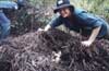
| The proposed project was to produce a nesting habitat database for the saltwater crocodile (Crocodylus porus) in the Top End of Australia. The project involved identifying nesting habitat of the saltwater crocodile using RS and GIS. The aim being to locate nesting sites that were currently not known about, thus enabling crocodile populations to be sustainably maintained in the landscape, whilst also allowing for the collection of eggs for crocodile farming. |
Examining a crocodile nest 26kb |
Background
Within the GIS/RS lab at CDU, there is an obvious familiarity with the capabilities of GIS and Remote Sensing, but individuals (here and within the partner organisation) had to recognise that there was a need to sustainably manage crocodile habitat, and that GIS and RS has great potential in this form of natural resource management.
|
![]()