
![]()
![]()
![]()
![]()
![]()
![]()
![]()
![]()
![]()
Data
Data requirements
Database design
Saltwater crocodile nesting habitat covers a range of wetland habitats including tidal rivers, floodplain creeks, billabongs, swamps and silted river channels. Saltwater crocodiles construct mound nests on riverbanks and floating mats of vegetation between November to May. Nests are thought to be more abundant where permanent freshwater is readily accessible.
Knowing these habitat criteria helps to determine the data requirements for the GIS. The following data capture methods can be suggested:
- Vegetation information could be derived from satellite imagery and field survey. This could take the form of a classification of a LANDSAT™ scene for the study site ground truthed with field survey vegetation data that was collected at locations where crocodile nest sites are known to occur.
- Point data of recorded nesting sites from field survey - this information has been collected by staff from Crocodylus Park - location information is recorded as x, y coordinates, these can be entered into the GIS using the keyboard or loaded from an Microsoft Excel file
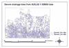
- Hydrography information can be obtained from the AUSLIG Topological GEODATA set at 1:250000 scale. This data is already digital and information is available for watercourses and waterbodies in the Top End of Australia.
|
Darwin drainage 15kb
|
Darwin waterways 12kb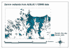
|
- Elevation information can be obtained from the AUSLIG 9 second DEM
![]()
In this case study the data could be organised so that there was a View consisting of nest data, one made up of water information, another containing land cover information and one containing elevation data. Within the crocodile database, streams and lakes can be grouped together in a hydrography layer. However, sometimes the limitations of the GIS software may mean that point, line and polygon features have to be stored in separate layers (Aranoff, 1989).
The choice needs to be made as to whether to work with vector or raster data structures or both. The decision normally depends on the format of the data you are working with. Land cover information derived from satellite imagery and elevation data are normally raster, whereas nest site data will be points and water information will be lines. In this instance it is probably easier to convert land cover and elevation to vector and work with a vector data structure for analysis.
Decisions alsoneed to be made about the type of database management system to use. This is often dictated by the GIS. Most to date are relational but object oriented database management systems are becoming more popular.
![]()