
![]()
![]()
![]()
![]()
![]()
![]()
![]()
![]()
![]()
Output
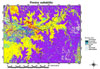
| The result in this case study is a GIS that can be used to determine suitable nest sites for saltwater crocodiles. An example of the output that can be generated from this GIS is a suitability map, showing locations of areas that are predicted as being suitable nesting sites. |
Finniss suitability 41kb |
![]()