![]()
![]()
![]()
![]()
![]()
![]()
![]()
![]()
![]()
![]()
![]()
![]()
![]()
![]()
GIS as a tool for landscape ecologists
GIS is a useful spatial analysis tool for understanding landscape patterns and variability through space and time using the following capabilities and functions.
Capabilities - The 5 M's!
|
Display of
flood zone on cadastral map 35kb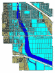
|
Functions
- Data capture (cartographic
elements)
- Data capture (attributes)
- Data manipulation
- Data analysis
- Display of data and analytical results