![]()
![]()
![]()
![]()
![]()
![]()
![]()
![]()
![]()
![]()
![]()
![]()
![]()
![]()
How a GIS works
|
The basis of a GIS involves building up a database of different
layers of information for the same geographical location which can
then be analysed. Data input to a GIS includes: |
Three different
GIS layers 25kb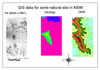
|
Maps
- Digitised information
- Scanning
- Remote sensing
- Downloading
- Remote access
Tables
- Attribute information
