![]()
![]()
![]()
![]()
![]()
![]()
![]()
![]()
![]()
![]()
![]()
![]()
![]()
![]()
Common terminology in GIS applications
| Terminology | Explanation |
| Spatial data | Spatial data is information that pertains to a particular location on the Earth's surface. This sort of geographical data is often referred to as georeferenced data. |
| Attribute information | Attribute information is the non-spatial information that helps describe features present in geographical space. |
| Database |
A database is a collection of one or more datafiles or tables stored in a structured manner. It is a collection of information about things and their relationships to each other. |
| Database Management System (DBMS) | A Database Management System is a software package for the storage, manipulation and retrieval of data from a database. |
|
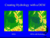
Digital Elevation Models (DEMs) Digital elevation model 29kb |
Digital elevation models are
|
For an explanation of other GIS terms, refer to the Glossary.
| http://www.geog.ubc.ca/courses/klink/ gis.notes/ncgia/u38.html will provide background reading on digital elevation models Try the discussion and exam questions if you would like to review your knowledge. |
||
| How would you now define GIS? How does this definition compare with the one you created at the start of this section? | ||