![]()
![]()
![]()
![]()
![]()
![]()
![]()
![]()
![]()
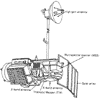
How does RS work?
| Electromagnetic energy (eg light from the sun) illuminates objects on the Earth's surface. As it does this some energy is absorbed by the object, some is transmitted through the object, some is emitted by the object and some is reflected back from the object. Emitted and reflected energy can be detected by sensors. | Energy detection 11kb 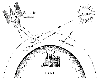
|
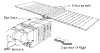
How remotely sensed data is
captured
|
SPOT satellite
Thematic Mapper satellite
Multi Spectral Scanner satellite |