QuickTime Video
Fire weather
Fire weather data is important because it describes the prevailing weather conditions affecting fire behaviour.
The most important weather variables are wind, atmospheric humidity and temperature.
Wind
Wind is a major controlling factor that determines rate and direction of spread, and shape of fire.
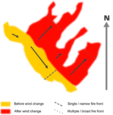
The following diagram illustrates the fire that can result from a change in wind direction.
Notice that a change in wind direction from the NW to SW has caused the flank fire to become the new fire front — much larger and potentially more difficult to control than the original narrow front.
Fire whirlwinds can form during or after fires, and are created by surface heating and atmospheric instability.
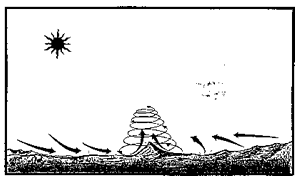
Fire whirlwinds
They can be problematic as they can carry burning debris outside the fire perimeter, sparking new fires.
Wind can also influence the likelihood of spotting. Spotting occurs when a fire produces sparks, embers or flaming material (such as loose bark) which are carried by the wind and start a fire ahead of the flaming front (outside the perimeter of the fire).
Humidity
Relative humidity (RH) is a measure of how much moisture is in the air. Expressed as a percentage, it describes the amount of water vapour in the air compared to the amount needed for the air to be saturated (i.e. 100% RH).
Humidity varies with temperature – as temperature increases humidity decreases (and vice versa). Humidity is important because it affects fuel moisture content and therefore its flammability. For example, in dry conditions, moisture from fuels is transferred to the atmosphere and the fuels become increasingly flammable. In the monsoonal tropics of northern Australia, this means that surface fuels become more flammable as the dry season progresses.
Activity: Humidity & temperature
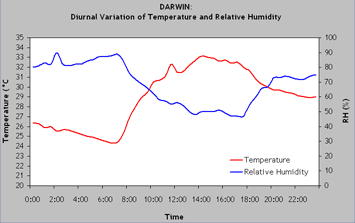
How does humidity vary diurnally?
The following graph illustrates the relationship between humidity and temperature. How do these vary diurnally?
(click image for larger view)
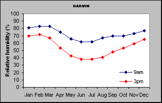
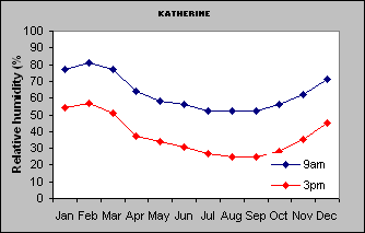
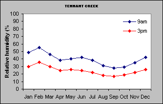
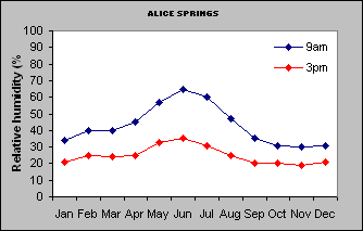
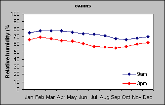
Now have a look at the graphs which show how relative humidity changes throughout the year in different regions of the Northern Territory, Queensland and Western Australia, and consider the following questions.
For locations of these sites refer to maps on the Geosciences Australia website.
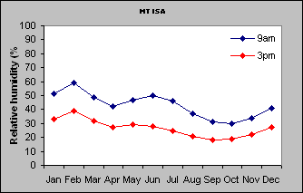
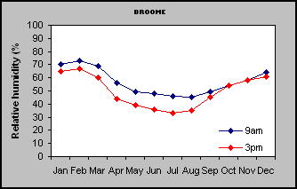
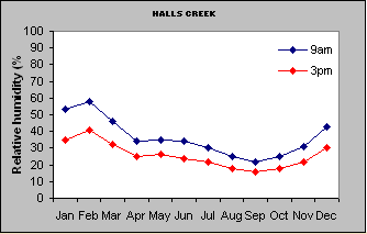
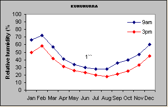
- Which months typically have the lowest humidity and which the highest?
- How does humidity vary across Northern Australia and how does it vary seasonally? What might this mean in terms of probability of fires?
- How might the direction of wind flow influence humidity (e.g. on-shore sea-breeze, as opposed to dry season wind from inland)?
1. North South transect from Darwin to Alice Springs
(click image for larger view)
(Click image for larger view)
(click image for larger view)
(click image for larger view)
2. East-west transect from Cairns to Tennant Creek
(click image for larger view)
(click image for larger view)
(click image for larger view)
3. South-west to north-east transect from Broome to Kununurra
(click image for larger view)
(click image for larger view)
(click image for larger view)
Temperature
Temperature affects fire behaviour indirectly through influence on fuel moisture content and local wind formation (e.g. sea-breezes). So, as air temperature increases, fuel moisture content tends to decrease, and vice versa. Dew can form which can cause fire to slow or even be extinguished.
Also, the higher the temperature of the fuel, the more easily it will reach ignition temperature.
Fire danger
Fire weather information can be used in conjunction with fuel information to provide indices of fire hazard or danger rating.
The Fire danger Rating (FDR) is an assessment of the potential fire behaviour, the difficulty of suppressing a fire and the potential impact on the community, should a fire occur on a given day. The FDR is determined by the Fire Danger Index (FDI). The FDI is a calculated using the degree of fuel curing, the air temperature, relative humidity, and wind speed for a given day.
Fire Danger Index (FDI) is estimated using the McArthur Fire Danger Meter for grasslands or forest. The higher the FDI, the higher the fire danger. The Mark IV Grassland Meter (or CSIRO Grassland Fire Danger Meter) is most applicable in the Northern Territory.

Mark IV Grasslands meter (click image for larger view).
There is also another CSIRO meter, the CSIRO Grassland Fire Spread Meter, which can be used to estimate rate of spread for grassy fuels in northern Australia.
Activity: Fire weather
How is fire weather measured and how does it relate to fire danger?
It’s important to know how these different aspects of fire weather can be measured. In the following video filmed in Darwin, Dr Dick Williams demonstrates how temperature, relative humidity and wind speed can be measured in the field. He will also explain how these aspects of weather are used to calculate fire danger.
| FDI | FDR | Definition & difficulty of suppression |
|---|---|---|
| 0 - 11 | Low- Moderate | - High humidity, rainfall, little wind and bush is damp. - Fires can be easily controlled. - Head attack easy with water |
| 12 - 24 | High | - High humidity, rainfall, little wind and bush is damp. - Head attack easy with water. |
| 25 - 49 | Very High | - Hot, windy conditions and the bush is dry. The use of open fires is prohibited. - Fires can be difficult to control. - Head attack will generally succeed for FDI up to approximately 40. For FDI greater than 40, head attack may fail except in favourable circumstances and close back burning to the head may be necessary. |
| 50 - 74 | Severe | - Very hot, windy and the bush is very dry. - Fires will be difficult to control and fast moving. - Direct attack will generally fail. Back burn from a good secure line with adequate manpower and equipment. Flanks must be held at all costs. |
| 75 - 99 | Extreme | - Very hot, windy and the bush is very dry. - Fires will be very difficult to control and fast moving. |
| 100 + | Catastrophic | - Fires will be unpredictable and very fast moving with highly aggressive flames.
- Fire will likely be uncontrollable |
Further Information
- Bushfires NT- Fire Danger Rating summary
- NT Bureau of Meteorology- Fire weather forecast
Activity: When would you burn?
How can fire danger hazard guide managers?
Given what you have just learnt about fire weather and measuring fire danger hazard, under what weather conditions could you (a) burn to put in fire breaks, and (b) burn off in close proximity to property?
Activity: Calculating Fire Danger
Can you work out the fire hazard?
Using the CSIRO Grassland Fire Danger Meter calculate the fire danger index for three different scenarios using weather data in the table below.
Three different scenarios for temperature, curing, relative humidity and wind speed to be used for calculating the Fire Danger Index (FDI) and the subsequent Fire Danger Rating (FDR). Variable Scenario 1 Scenario 2 Scenario 3 Curing (%) 95 70 75 Temperature (C) 28 28 30 Relative Humidity (%) 20 40 60 Wind Speed (m/s) 30 30 20 FDI ? ? ? FDR ? ? ? What time of the year and under what conditions might you expect each of these scenarios?
Activity: Fire weather in the monsoonal north
How does topography influence fire behaviour?
Finally, have a look at the Bushfire Weather which has been produced by the Bureau of Meteorology. It provides a good overview of weather and fire.
How might you expect different elements of fire weather to vary in the early dry season and late dry season? You might find it useful to check out the Bureau of Meteorology website.