Fuel dynamics & characteristics
Fuel type and load
Fuel type and quantity in an area can play an important role in determining the types of fires as well as fire intensity. Fuels vary in their structural form, size (fine or coarse), and spatial arrangement (surface or elevated).
Activity: Types of fuel
What types of fuel are there in the tropical savannas?
There are a range of fuel types in savannas. In this video Dr Dick Williams talks about some of the different types of fuel found in tropical savannas. The video was filmed on location at the Territory Wildlife Park.
QuickTime VideoWatch fuel types
Fuel types can play an important role in fire behaviour. Ladder fuels with loose bark (e.g. Melaleuca trees or Pandanus) may cause spotting outside of the fire perimeter. Ladder fuels also enable flames to reach the top of vegetation.
Activity: Pandanus as ladder fuels
How do Pandanus act as ladders?
The dead leaves from Pandanus trees can act as a ladder to swiftly draw fire up the trunk to the top of the tree.
QuickTime VideoWatch Pandanus blaze
Activity: Identifying fuel types
What type of fuels are most common in different vegetation types?
How do fuel characteristics vary among (a) a pine plantation (b) a tropical savanna, and (c) a grassland. Think about fuel load, fuel type and size, spatial arrangement, and wind penetration in each habitat.
Start this activity by reading Bowman & Wilson (1988) in which the fuel characteristics of a monsoon rainforest are described.
After the reading, consider the fuel characteristics of the area you live in. How would you characterise them?
Reading:
Bowman, D.M.J.S. & Wilson, B.A. (1988) Fuel characteristics of coastal monsoon forests, Northern Territory, Australia. Journal of Biogeography 15: 807-817.
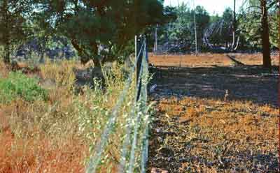
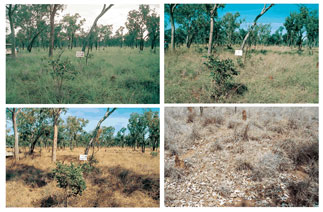
Fuel loads change over time — annually, seasonally and diurnally. In wet years fuel loads may be higher and more continuous, while in dry years there may be little fuel for fires. Fuel loads can also be controlled to some extent by people. For example, land uses such as grazing can reduce fuel loads. The picture below illustrates the impact of rabbit grazing. Rabbits have been excluded on the left side of the fence.
Fuel loads under different grazing regimes
The pictures below illustrate differences in fuel load (kg/ha).
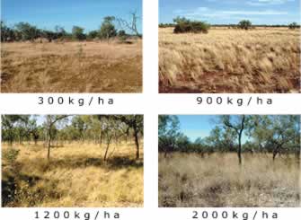
Differences in fuel loads (click image for larger view)
These pictures come from the North Australian Fuel Guide (pdf document) which was developed to assist land managers to visually estimate fuel loads). Have a look at the booklet to see a greater range of fuel loads than those shown below.
Fuel load is important because it influences the intensity of fire, as illustrated in the following diagram.
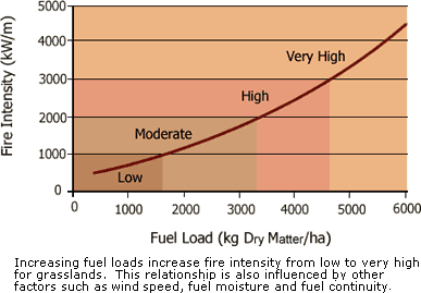
Relationship between fuel load and intensity of fire
Activity: Fuels & season
How does fuel load vary between the early and late dry season?
Data on tropical savanna fuels are presented in Williams et al. (2003) who report on the Kapalga fire experiment in Kakadu National Park.
After reading the chapter consider how and why fuels vary between the early dry season and late dry season.
Reading:
Williams, R.J., Gill, A.M. & Moore, P.H.R. (2003) Fire behaviour. In: Fire in Tropical Savannas (A.N. Andersen, G.D. Cook, R.J. Williams, eds.), p. 195. Springer-Verlag, New York.
How is fuel load measured?
There are three main techniques available to measure herbage biomass (fuel load): (1) direct harvest methods, (2) estimation techniques and (3) indirect methods.
(1) Direct harvesting:
This is the most accurate method for fuel estimation, but is not always practical. This method involves taking clippings from a known area (e.g. ring or square quadrat of known area), oven-drying and then weighing the samples. Oven dried weight can be converted into t/ha.
Disadvantages with this method include relatively time-consuming and expensive procedures.
(2) Estimation techniques:
Disc-pasture meter: For grassy fuel loads, one of the most efficient methods for estimating fuel load is the disc-pasture meter. This technique involves a base plate which slides up and down a calibrated aluminium rod. There is a relationship between the settling height of the base plate and the standing crop of the grass below. The meter has been calibrated for a variety of grassland and savannas, particularly in Africa. There are problems with this technique as it cannot be used to estimate woody fuel loads, and estimations may be affected by rocks holding up the base plate, rather than grasses.
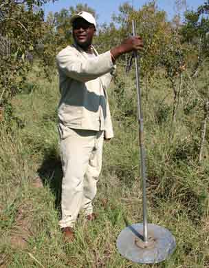
Disc-pasture meter used in a South African savanna
Further reading
Have a look at the following A falling plate meter for estimating pasture forage mass (pdf document) to see the construction of a disc-pasture meter and its calibration. Source: West Virginia University, Extension Service.
Calibrated visual estimation techniques: Visual estimation techniques usually involve double sampling procedures for calibration purposes. The dry-weight rank (DWR) method involves the visual estimation of biomass with estimates calibrated with actual fuel loads prior to sampling. These estimation methods are designed to provide a rapid assessment of herbage mass for extensive rangeland surveys. Importantly they require observers with experience at estimating herbage biomass.
Fuel mapping with remote sensing: This is a landscape scale approach to fuel estimation. This approach includes direct mapping which assigns fuel characteristics based on results of image classification or photo interpretation, and indirect mapping which derives fuel information based on vegetation cover information (i.e. vegetation is a surrogate for fuel type and load).
(3) Indirect methods:
Precipitation can sometimes be used to predict end-of-season biomass provided there is a good relationship between the two.
Activity: Measuring fuel load in the field
What is involved in direct harvesting of fuel?
As a class measure fuel loads in (a) a variety of different habitats, and (b) compare measurements of fuel load from grazed and ungrazed areas.
Do they vary and why might this be?
If your class is using a variety of techniques — compare the results that you get from the different methods.
How much variance is there, and why do you think this might be?
Fuel Curing
With prescribed burns, fires are often started in the morning when the fuel moisture is highest, and fires are easier to control.
Thus, land managers can use the diurnal and seasonal change in fuel moisture to their advantage to achieve different types of fires. For example, if land managers wish to use hot fires to control woody weeds, lighting fires towards the middle of the day when fuel moisture is lowest can help achieve a hotter fire.
How well grass burns is related not only to height, mass, composition and architecture, but also to how cured it is.
Curing refers to how green the fuel is. Unlike fuel moisture, variation in curing is considered primarily in terms of seasonal rather than daily change. Green grass has high moisture content while brown grass is dry with much lower moisture content.
Activity: Vegetation curing
What is vegetation curing?
The change from green, moist vegetation to browner, dry vegetation and what this means in terms of fire is discussed by Dr Dick Williams on location in Darwin.
QuickTime VideoWatch vegetation curing
Have a look at the pictures below which illustrate differences in curing. These pictures come from the North Australian Fuel Guide. Have a look at the 'North Australian Fuel Guide booklet' (pdf document) to see how curing varies with different soil types.
Fuel curing (click image for larger view)
Further reading
More information about curing and what it means is given in Savanna Burning.
Reading:
Dyer, R., Jacklyn, P., Partridge, I., Russell-Smith, J. & Williams, R. (2001) Savanna Burning: understanding and using fire in northern Australia, p.19. Tropical Savannas CRC, Darwin.
Activity: Fuel curing
How and why measure fuel curing?
There are several reasons why it is important for managers to know about fuel curing rates.
Find out how fuel curing is important to fire managers, and how it can be monitored using satellite imagery by reading Savanna Burning, pp. 116-118.
Reading:
Dyer, R., Jacklyn, P., Partridge, I., Russell-Smith, J. & Williams, R. (2001) Savanna Burning: understanding and using fire in northern Australia, pp. 116-118. Tropical Savannas CRC, Darwin.
Fuel moisture
Fuel moisture can vary temporally (daily, seasonally and annually) as well as spatially; vegetation communities will vary, and even within an area local differences in rainfall can result in small-scale differences in moisture and curing.
Fuel moisture is most often assessed either through direct measurement or by inference using another variable. Direct measurement involves taking samples of fuel, weighing it, drying it in an oven, and then re-weighing it. This approach relies on adequate sampling to overcome problems such as variability across a site.
Using remote sensing to estimate fuel moisture
Remote sensing is not only useful for estimating fuel loads; it can also be used to predict fuel curing. NDVI (Normalised Difference Vegetation Index) derived from satellite images allows fuel greenness or curing to be assessed remotely.
Activity: NDVI (1)
How does moisture change temporally & spatially?
The Bureau of Meteorology service provides access to browse images (1:10 resolution) of Monthly NDVI (Normalised Differential Vegetation Index Maps). NDVI is used as an indication of how green vegetation is.
Explore this website which shows NDVI across Australia.
See if you can chart how NDVI changes over the course of a year, and how this varies seasonally in the Top End.
Now, compare changes in NDVI between the Top End, and south-western Australia.
Resource:
Australian Bureau of Meterology (2005). Normalised Difference Vegetation Index http://www.bom.gov.au/climate/maps/ Browse service website. Accessed July 2013.
Activity: NDVI (2)
Can NDVI predict fuel curing?
Predictions of greenness or curing can assist with the success of prescribed burning operations. The following study found that there was a significant relationship between ground-based estimates of curing and estimates of relative greenness derived from NDVI images from satellites.
Reading:
Allan, G., Johnson, A., Cridland, S. & Fitzgerald, N. (2003) Application of NDVI for predicting fuel curing at landscape scales in northern Australia: can remotely sensed data help schedule fire management operations. International Journal of Wildland Fire 12: 299-308.
![]()