![]()
![]()
![]()
![]()
![]()
![]()
![]()
![]()
![]()
![]()
![]()
![]()
Raster
|
Raster can also be referred to as a grid (or cell-based) data structure. Space is divided into regular cells (usually square) so information is stored as a grid or cells/pixels. |
Raster DEM 18kb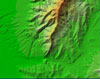
|
- The location
of each object is defined by the row and column position of the cells
that they occupy.
- The area of each cell
defines the spatial resolution of the data set.
- The value for each
cell defines the type of object present at that location. Each grid
cell has attribute values.
The two-dimensional array of cells for a particular
theme is called a coverage.
Both vector and raster approaches represent spatial
information as homogeneous units. In the case of the vector approach,
homogeneous units are points, lines and polygons. In the case of the raster
approach, homogeneous units are cells.
Advantages and disadvantages of vector data structures
| Advantages | Disadvantages |
|
|