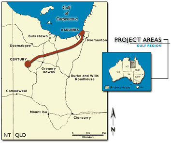
Case Study 1: Design, plan and cost fauna surveyBackground information Tenders have been called to submit detailed proposals for the FAUNA component of the IAS. Your company (Feral Enterprises Pty Ltd) is a leading ecological consultant based in Darwin with extensive experience in undertaking fauna surveys. You see this as an excellent opportunity to display your companies' talents. No previous fauna surveys have been done in the region, although numerous museums have gathered a number of specimens from ad hoc collecting. It is believed that a number of rare and endangered species occur in the region. These include the Painted Turtle (Emydura subglobosa), Gouldian Finch (Erythura gouldiae) and Carpentarian Antechinus (Pseudantechinus mimulus). A large number of Aboriginal sacred sites are located in the project area. The traditional owners, the Waanyi people, live in a small community nearby. Disused mine shafts are common in the area, a legacy of small-scale mining at the start of the century. Aims
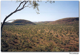
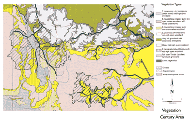
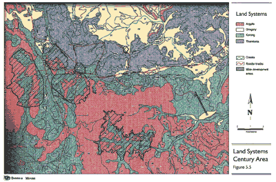
Location of project area The region is sparsely populated with limited infrastructure. The region is located in the tropical savanna and the vegetation, which consists of scattered trees with a grass understorey, is largely intact. The landscape is characterised by flat alluvial plains and low rocky ranges. The climate is monsoonal, with a short wet season (December to March) where an average of 500 mm of rain falls followed by a long dry season (April to November). An area of 2,585 ha will be cleared for the mine site (shaded areas on the vegetation map below). No accommodation facilities are available, and no airstrip within 50 km. A number of pastoral stations are located 20 km away. Vegetation Woodland communities Terminalia canescens & Atalaya hemiglauca mid-high open woodland occurring on flat areas Eucalyptus leucophloia open mallee woodland occurring on steep slopes of sandstone hills Eucalyptus leucophloia open mallee woodland with mixed understorey occurring on rocky outcrops Eucalyptus pruinosa mid-high open woodland occurring on alluvial plains Eucalyptus terminalis mid-high woodland occurring on limestone formations Grassland communities Very tall grassland occurring on flat alluvial plains Triodia (spinifex) hummock grassland occurring on sandstone hills and footslopes Riparian community Eucalyptus camaldulensis tall open forest with mixed understorey occurring next to intermittent creek lines Land systems Argylla - dissected hills with much rock outcrop. Skeletal soils and Upper Proterozoic geology comprising siltstone and sandstone. Gregory - grassland plains of mainly cracking black clay soil alluvia. Late Tertiary to Quaternary geology. Korong - gently sloping, mildly dissected lower parts of footslopes with variable soils comprising sand, gravel clay and silt. Cainozoic (Pliocene) geology. Thorntonia - rough limestone rocky hills comprising some dissected plateaux and mesas. Skeletal soils and Middle Cambrian geology.
In your proposal make sure to include the following information Length 1500-2500 words (please don't go over this limit) As part of your proposal be sure to fully describe the following sections: 1.Title
5. Costs, time and staff required
6. References
|