What is the status quo?
Prior to the 1990’s detailed information on water resources produced by the Government Department responsible, was largely presented in a highly scientific format. The work program at that time was centred on gaining a secure supply of water to towns and communities and the need to develop sustainable water supplies for industry including the pastoral, horticultural, agricultural, tourism and mining sectors. Often the work was focused on the provision of one or more production bores for a community or a specific proposed development. Written reports were directed towards other water resource scientists/engineers and development planners. The reports were not intended to be read by the wider community. In the 1990’s the emphasis of the work program shifted to identifying water resources with a significant wider regional development potential focus.
This refocus, combined with the initiatives of the National Landcare Program, has resulted in investigation programs now being targeted at providing value added data for a wider audience.
The Natural Systems Division of NRETA has over the last few years, undertaken regional water resource mapping projects on
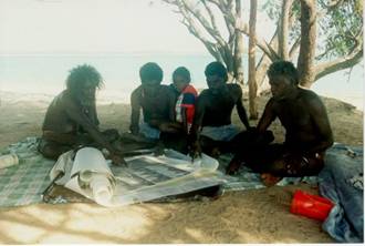
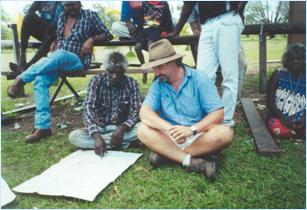
These projects have sought to include Aboriginal knowledge and perspectives on water, thereby providing cross-cultural education and general awareness of water resources. This combined knowledge can assist non-aboriginal land managers in understanding social issues pertaining to land and water management, enabling appropriate decisions to be made. It has been the intention of the water studies that the maps and reports be used for those purposes.
Other initiatives to incorporate two knowledge systems have come about as a result of water allocation planning. For example a Water Allocation Plan for the Ti-Tree Region was initiated by the Government as a result of the need for appropriate water management due to increasing demand for groundwater resources in the region. The plan was presented in the form of a Ti-Tree Region Water Resources Strategy 2002. The document is suggested to be a starting point for better understanding the balance between development and the resource and acts as a guide for future assessment, planning and management activities.
Within the chapter entitled Cultural and Environmental Uses the following statement was made:
In the absence of any clear knowledge to the contrary, it is assumed that regional groundwaters have no cultural significance and it is similarly assumed that there are no ecosystems reliant on shallow groundwater aquifers. Regional surveys will be necessary to test these assumptions. (DIPE 2002)
As a result of the obvious need to investigate that assumption, the Recognition of Indigenous rights and cultural knowledge in the management of inland waters project is currently being coordinated thru the
This has already begun in the