 |
Magpie Goose Survey - A Case Study
Note: although based in fact, the data and scenarios presented in this tutorial have been simplified and adapted to suit the current purpose.
- Background
- The role of spatial technology in survey work
- Collate existing data
- Process data to suit the survey aim
- Sampling strategy
- Fieldwork
- Spatial analysis
- Extrapolate
- Evaluation and outcomes
- Acknowledgments
Background![]()
Magpie Geese (Anseranas semipalmata) are an important natural
resource in the Northern Territory as the species is a significant component
of the fauna of floodplains, provides food for Aboriginal communities,
sport for hunters, and is highly visible making it a key tourist attraction.
Distribution patterns of the Magpie Goose in Australia are known to have
diminished since the arrival of Europeans and conservation of the species
is an issue of concern to wildlife managers in northern Australia. The
NT Parks and Wildlife Commission have conducted surveys of Magpie Geese
and their nests on an annual basis for many years in order to gain a better
understanding of the ecology of the species, its distribution and abundance,
and habitat relations.
A subset of this data - a single year (1993) in a single catchment (Mary River) - has been selected to illustrate the important role that spatial technology plays in the ongoing collection and analysis of this data. A typical sequence of events relating to the planning and execution of surveys in the field and the subsequent integration and analysis of the data into a geographic information system is portrayed.
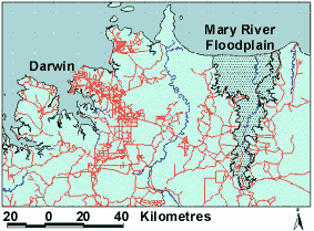
Figure 1: The Mary River Floodplain in the Top
End
of the Northern Territory.
The
role of spatial technology in survey work![]()
Spatial information has a role to play before, during and after surveys.
A typical sequence for Magpie Geese might be as follows.
Before the survey
- collate existing data (and understand the study area)
- process data to suit the survey aim
- determine the most appropriate sampling strategy
During the survey
- field maps and navigation
- GPS location fixes
- record the collected data.
After the survey
- analyse the sampled data
- extend the results to areas not surveyed
- evaluate and verify results
- report outcomes and recommendations to management.
A section for each of the above headings follows. Each section contains a brief overview of the role of spatial information at that point and is accompanied by a more specific description of the Magpie Goose survey. Each of these is accompanied by illustrative maps, tables, and other spatial information from the geographic information system as appropriate.
|
Baseline database: Before details of a survey are planned all relevant existing data should be identified and acquired. Where the survey is part of an existing monitoring process then this might only entail identifying data captured since the previous survey. If it is a new initiative then the process may involve considerable preparation. It is important at this point that data are standardised so that they may be compared and analysed (for example, they should all be digital, georeferenced, and use the same map datum and projection). |
A baseline database would normally contain topographic data such as drainage,
roads, places and elevations to provide a context for the more specific
datasets associated with the study. In this study of Magpie Geese, baseline
digital data is AUSLIG TOPO 250K data at 1:250,000 scale (see
Figure 1). Datasets specific to this project and available for this
area included a vegetation map compiled by D. Lynch of the Department
of Lands, Planning and Environment. The vegetation map describes 47 vegetation
types within the Mary River floodplain area and is illustrated in Figure
2. It is known from detailed ecological studies that Magpie Geese
favour specific habitats for nesting, feeding and roosting. This vegetation
map will then be used to provide the underlying framework onto which survey
data can be mapped and finally presented.
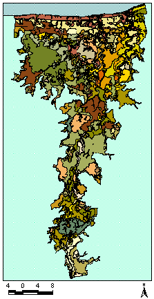
Figure 2: Vegetation Map of the Mary River Floodplain by D. Lynch,
1996 (abbreviated legend).
|
Data exploration: It is sensible at this point to review the existing data in terms of both spatial features and other attributes and consider the implications these might have for the survey procedure. If data have been collected at a certain scale, accuracy, and precision in the past then it is usually best to maintain these in order to allow comparison among the data collected. If the survey is a new initiative then decisions will have to be made regarding these aspects of data collection. A decision will have to be made about how applicable previous methodologies and data design and management are to the current study. It may be helpful to look to archived remotely sensed data for clues as to the major patterns and processes at work in the environment. |
The vegetation map by Lynch contains information on 47 vegetation communities in the Mary River floodplain. These spatial units are linked in a database table to other attributes. Attributes available for each vegetation type include the area and perimeter measurements for each vegetation community. Data is often collected for specific projects and may need to be processed before it is suitable for use. Typical data exploration would include a description of the area covered by each community and the proportion of area each community comprises of the total area. This information is needed to determine whether the data was suitable for this project and help in determining the suitability of different sampling strategies.
Figure 3: Subset of the Lynch vegetation map with legend to indicate vegetation classes.
|
Vegetation Community |
Area (km2) |
|
Intertidal areas |
57 |
|
Mangrove community composed of Avicennia marina and associated species |
16 |
|
Samphire plains and bare areas |
15 |
|
Mixed herbs |
30 |
|
Sedgeland on upper coastal plain |
66 |
|
Chenier beach ridge with sand and shell fragments |
3 |
Table 1: Subset of vegetation classes in Lynch vegetation map,
the area of each community has been calculated.
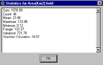
Figure 4: GIS functions includes statistical analysis of fields
in a table.
In this case 46 vegetation communities covering 1,078 square kilometers.
Process to suit the survey aim![]()
|
Generalisation of data: At this point, whether we are using remotely sensed data or interpolated data, we usually have more detail than we need for most purposes. Classification is the traditional method in Western science for reducing data to categories that are useful for particular purposes. Categories encapsulate and summarise the attributes of interest for the task at hand. In effect the data is generalised. Typical environmental classes are vegetation communities or soil types where areas with similar characteristics are pooled and treated as a single spatial feature, despite the variation on the ground within each class. In a GIS, generalisation of data can be achieved by simply reclassifying detailed datasets. |
The Lynch vegetation map is based on a combination of vegetation floristics and structure and soil type. This level of detail is more than is necessary for estimating goose numbers and generalisation of the data was achieved by reclassifying the map into 18 classes. These classes were suggested by Peter Whitehead on the basis of his work on the autoecology of the Magpie Goose. These new units were based solely on floristics and structure and not on other variables. The effect of generalisation on the display of the map can be seen in Figures 5 & 6.
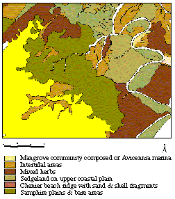
Figure 5
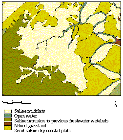
Figure 6
|
Sampling strategy: Based on the review of existing datasets, a sampling strategy can now be determined. What data can be collected using remotely sensed data and what needs to be collected in the field? The GIS can help to answer many questions at this point. For example, ease of access to the area of interest, topographic characteristics, cultural influences such as roads and fences, area of interest, location and characteristics of areas of special interest, influence of scale and resolution? Sampling grids or transects can be generated and costs calculated. The sampling strategy must of course take into account the future handling of the data such as interpolation and extrapolation techniques to be applied. |
Sampling extensive floodplains during the wet season at the resolution required to observe individual Magpie Geese can only be achieved in an effective manner using aerial survey techniques. Initial calculations of flight times and costs can be gained by plotting the transects over the area of interest, calculating their total length, and examining the vegetation communities they cross to ensure than a representative sample is obtained - that is, that your sampling is 'stratified' with respect to vegetation unit. An east-west system of transects was designed at intervals of approximately 5 kms. This provided a total transect distance of 1142 kms and provided a representative sample of vegetation communities proportional to the total area of each community.
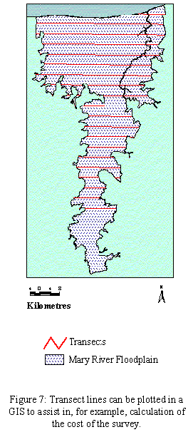
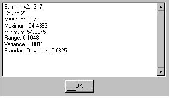
Figure 8: Total length of the 21 transects required to survey the
study area can be calculated in a GIS. The cost of the survey can be estimated
from this information.
|
Fieldwork: Fieldwork can be facilitated with maps specifically generated for the field, GPS for locating selected samples or ground-truthing sites and technology for feeding the locational data directly into a portable computer. This enables field workers to see where they are on a map or image and to enter attribute data for their current location directly into the database or a logger. It is important at this point to have an understanding of errors that may be inherent in the sampling approach and/or equipment used and keep these to a minimum. |
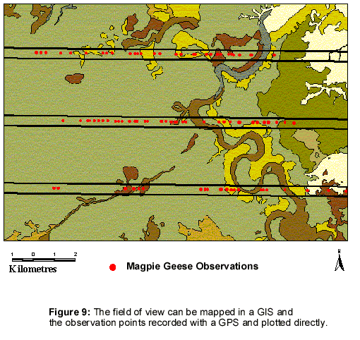
Observers on both sides of the aircraft counted geese and recorded their observations frequently. The field of view for counting was 200 meters on each side of the aircraft which provided a 400 m swathe along the flight path. A GPS was used to register the geographic coordinates of each goose observation and the coordinates and the count entered into a data logger in real time. Maps prepared specifically for the survey were marked with the time and direction of flight for each transect.
|
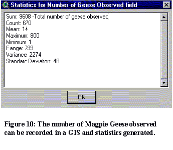
Analysis: Spatial analysis is used to transform the data collected into information that can be used for decision-making purposes. For example, this information includes the measurement of newly identified patterns; the analysis of change over time in the nature and abundance of species and communities of interest, within the domain of interest; the (re)evaluation of species/habitat associations; and correlation with other information on processes leading to change (e.g. fire). |
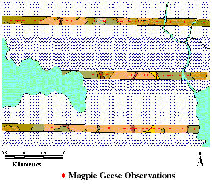
Figure 10: The vegetation sampled can be derived from the GIS,
further analysis can then indicate the density of geese found in each
community type.
|
Vegetation |
Number of Geese Observed |
Area (km2) |
Geese/km2 |
|
Backswamps |
77 |
2 |
36 |
|
Billabongs |
107 |
1 |
83 |
|
Chenier/beach ridges and other elevated sites |
198 |
2 |
106 |
|
Floodplain, grassland\sedgeland with good representation of Oryza spp. |
933 |
20 |
48 |
|
M. viridiflora woodland |
142 |
3 |
46 |
|
Melaleuca woodland |
1413 |
35 |
41 |
|
Mimosa pigra |
43 |
2 |
21 |
|
Mixed grassland |
1153 |
12 |
97 |
|
Open water |
158 |
2 |
88 |
|
Paleochannels with Hymenachne spp. grasslands |
2012 |
19 |
109 |
|
Saline intrusion to previous freshwater wetlands |
89 |
4 |
22 |
|
Saline mudflats |
557 |
13 |
44 |
|
Sedges, herbs and grasses |
1903 |
6 |
333 |
|
Semi-saline dry coastal plain |
730 |
14 |
51 |
|
Upper alluvial plains |
22 |
2 |
14 |
|
Variable grassland |
71 |
2 |
40 |
|
Total |
9608 |
139 |
69.1 |
Table 2: Density of geese found within each vegetation type can be calculated using a GIS.
The"reclassified" vegetation map provides information on vegetation communities included within the sampled area (Figure 10). The area sampled can be derived from within the GIS by mapping the transects and then creating a buffer around the data to account for the field of view of the flight path flown. Analysis within the GIS can then provide information on the area for each vegetation type within the sampled area and the number of geese observed in each of these. The density of geese for each vegetation community can then be derived. This information provides a quantitative assessment of which community types Magpie Geese favoured at the time of the survey and provides a starting point for understanding the habitat relations.
|
Extrapolate: In northern Australia the domain of interest is often far too large to be sampled in total. In these cases results of sampled areas must be used to predict the value of an attribute at sites outside the area covered by existing observations. This process is called extrapolation and once again GIS and remote sensing technology offer the best potential to achieve this. This can be compared to interpolation, which is also used to predict missing values. However, interpolation is used to predict the value of an attribute at sites within the sampled area, but where actual samples were not obtained. |
By using a GIS to analyse the information gained during the field trip
in association with vegetation types, the density of Magpie Geese within
each vegetation type could be estimated for the sampled area. This data
can be used to estimate the density of Magpie Geese throughout the total
floodplain. This is done by 'scaling up' the count data by the ratio of
sampled vegetation to total vegetation communities. For example, if 100
geese were observed in 100 km2 of community type A, a density of 1 goose/km2
can be calculated. If the total area of community A is 300 km2
then the total Magpie Geese population can be estimated at 300 for this
community. In this way the total population in the area can be estimated
in addition to the relative preferences for different community types.
|
Vegetation |
Geese per Km2 |
Total area of vegetation(Km2) |
Estimated no. of geese in each vegetation community |
|
Backswamps |
36 |
13 |
468 |
|
Billabongs |
83 |
9 |
747 |
|
Chenier/beach ridges and other elevated sites |
106 |
16 |
1696 |
|
Floodplain, grassland\sedgeland with good representation of Oryza spp. |
48 |
126 |
6048 |
|
M. viridiflora woodland |
46 |
19 |
874 |
|
Melaleuca woodland |
41 |
258 |
10578 |
|
Mimosa pigra |
21 |
14 |
294 |
|
Mixed grassland |
97 |
86 |
8342 |
|
Open water |
88 |
15 |
1320 |
|
Paleochannels with Hymenachne spp. Grasslands |
109 |
133 |
14497 |
|
Saline intrusion to previous freshwater wetlands |
22 |
23 |
506 |
|
Saline mudflats |
44 |
102 |
4488 |
|
Sedges, herbs and grasses |
333 |
43 |
14319 |
|
Semi-saline dry coastal plain |
51 |
96 |
4896 |
|
Upper alluvial plains |
14 |
34 |
476 |
|
Variable grassland |
40 |
15 |
600 |
|
Total |
- |
1002 |
70149 |
Table 3: Total numbers of geese in the floodplain system can be calculated using field data in a GIS.
|
Evaluation of results: This is the point at which the results of the survey are assessed in the context of past information and combined with information collected from other sources. This evaluation should result in refinements being made to the models of pattern and process used for management purposes and possibly to the database itself. It may, for example, become clear that the scale or resolution of data is not providing all of the information required. |
Results can be evaluated by comparison with results from previous years
and catchment areas. Sampling strategies can be reviewed in light of the
results obtained. For example, when the transects flown were assessed
against the reclassified Lynch vegetation map, it became apparent that
not all vegetation types were represented in the sample. The missing vegetation
types could not be analysed for the occurrence of magpie geese. Future
sampling strategies should include all vegetation types to find occurrence
of magpie geese, and additional sampling may be scheduled.
|
Decide: The end result of the survey is the input of the spatial modeling results into the management decision making process. Survey results are weighed along with other information (for example, legal and political requirements) and a decision is made on a course of management action which is then implemented. The cycle outlined then starts again. |
After evaluation of the results and methodology used, techniques of analysis
can be refined and applied to datasets. An example of this is the application
of the methodology to analyse density of Magpie Goose nests on the Mary
River floodplain. The methodology could also be applied to other catchment
areas, for other species and at other times.
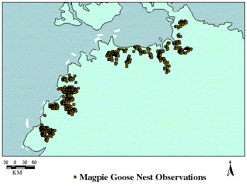
Figure 12: Illustrates the extent of the 1993 survey of Magpie Geese
nests across the Top End of the Northern Territory. Evaluation of results
from individual areas can be compared.
Acknowledgments
This case study was prepared by Chris Devonport and Janice Crerar.
The following people and organisations are acknowledged for their contributions:
Dr. Peter Whitehead, Mathew Fegan and Tom Colley of the Charles Darwin University; D. Lynch of the Department of Lands, Planning & Environment
and; Keith Saalfeld of the NT Parks & Wildlife Commission.